Mount Rainier is a massive stratovolcano located 54 miles (87 km) southeast of Seattle in the state of Washington, United States. It is the most topographically prominent mountain in the contiguous United States and the Cascade Volcanic Arc, with a summit elevation of 14,411 feet (4,392 m). Mt. Rainier is considered one of the most dangerous volcanoes in the world, and it is on the Decade Volcano list. Because of its large amount of glacial ice, Mt. Rainier could potentially produce massive lahars that would threaten the whole Puyallup River valley.
On clear days it dominates the southeastern horizon in most of the Seattle-Tacoma metropolitan area to such an extent that locals sometimes refer to it simply as "the Mountain." On days of exceptional clarity, it can also be seen from as far away as Portland, Oregon, and Victoria, British Columbia.
With 26 major glaciers and 36 square miles (93 km2) of permanent snowfields and glaciers, Mount Rainier is the most heavily glaciated peak in the lower 48 states. The summit is topped by two volcanic craters, each more than 1,000 feet (300 m) in diameter with the larger east crater overlapping the west crater. Geothermal heat from the volcano keeps areas of both crater rims free of snow and ice, and has formed the world's largest volcanic glacier cave network within the ice-filled craters, with nearly 2 miles (3.2 km) of passages. A small crater lake about 130 by 30 feet (40 by 9.1 m) in size and 16 feet (5 m) deep, the highest in North America with a surface elevation of 14,203 feet (4,329 m), occupies the lowest portion of the west crater below more than 100 feet (30 m) of ice and is accessible only via the caves.
From Wikipedia
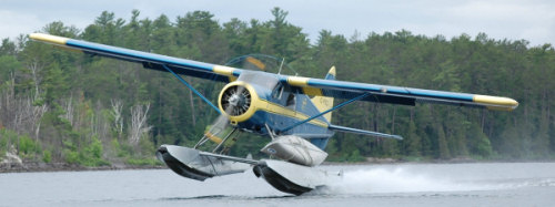
I made a poor choice of aircraft for this flight.........no shots from above the mountain :-/


Thanks 4 looking
On clear days it dominates the southeastern horizon in most of the Seattle-Tacoma metropolitan area to such an extent that locals sometimes refer to it simply as "the Mountain." On days of exceptional clarity, it can also be seen from as far away as Portland, Oregon, and Victoria, British Columbia.
With 26 major glaciers and 36 square miles (93 km2) of permanent snowfields and glaciers, Mount Rainier is the most heavily glaciated peak in the lower 48 states. The summit is topped by two volcanic craters, each more than 1,000 feet (300 m) in diameter with the larger east crater overlapping the west crater. Geothermal heat from the volcano keeps areas of both crater rims free of snow and ice, and has formed the world's largest volcanic glacier cave network within the ice-filled craters, with nearly 2 miles (3.2 km) of passages. A small crater lake about 130 by 30 feet (40 by 9.1 m) in size and 16 feet (5 m) deep, the highest in North America with a surface elevation of 14,203 feet (4,329 m), occupies the lowest portion of the west crater below more than 100 feet (30 m) of ice and is accessible only via the caves.
From Wikipedia
I made a poor choice of aircraft for this flight.........no shots from above the mountain :-/
Thanks 4 looking


 Anyway, I think my next one will be Denali (aka Mount McKinley ) in Alaska. If you have a scenery with that mountain in it, I'd love to do some recon off of your screenshots