I'll use the Garmin GNS 530 simulator available here:
http://www8.garmin.com/include/SimulatorPopup.html to show you how to do it.
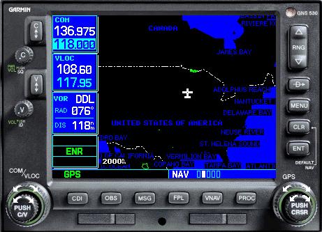
The GPS (actually a GNS, Global Navigation System) starts off in the overhead map navigation page, I'll call it the "home" screen shown below:
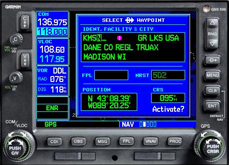
You need to first select a destination. Do this by pressing the "direct" button, the button that looks like a "D" with a line through it, right below the range button. That will bring up this screen (I've already entered KMSN as my destination):
Next, type in your destination using the knob on the bottom right. Use the outer ring to select the place of the letter, and the inner ring to select the individual letter (for example, find "K" with the inner ring, then use the outer ring to go to the next position, then use the inner ring to find "M" etc...). Once your destination is entered and you see that it shows the name of the airport, press the "ENT" key, then "ENT" again to activate the navigation. Once you activate it, the GPS will return to the home screen, and a purple course line will connect you to your selected destination.
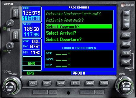
Next, to select an approach, press the "PROC" key. That will bring up a screen like this:
On this screen, you want to highlight the "Select Approach?" option using the outer ring of the bottom right knob again. It should already be highlighted when you get to this screen, but if it's not, choose it. Press "ENT". Once you press "ENT", this screen will come up:
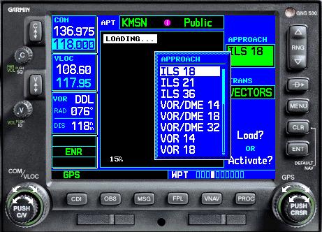
From this list, select the approach you plan on flying. It's important to note that you can only fly RNAV or GPS approaches (maybe NDB approaches too) using the GPS as your primary navigation source. Highlight the approach you want to fly using the outer ring of the lower right knob, and press "ENT" once your selected approach is highlighted. This will bring up this screen:
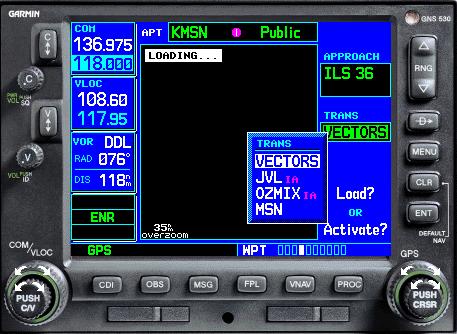
This screen shows a list of all the initial approach fixes for your selected approach. You'll want to choose the IAF most appropriate for where you are coming from (if you're coming from the north, don't choose the IAF that's 20 miles south of the airport, unless it's the only one available). You can also choose "VECTORS" meaning ATC will direct you onto the approach course with radar vectors. Once you choose your IAF, press "ENT" and this screen will come up:
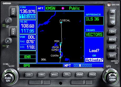
Highlight the "Activate?" option using the outer ring of the lower right knob and press "ENT". If you chose any approach other than an RNAV or GPS approach, a message will come up telling you that the GPS is for monitoring only etc. Highlight "Yes?" and press "ENT". This screen will come up:
Once this screen is up, you can press "CLR" to return to the home screen where you will see a map with a purple course line from your aircraft to the IAF you selected. You should then be ready to intercept the approach course and fly the approach (using the proper nav equipment if you're not flying an RNAV approach).
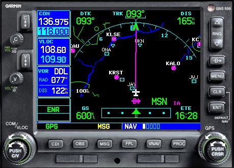
Finally, you may find it easier and more helpful to fly using the first nav page. You get to it by pressing to the left on the inner ring of the bottom right knob. This page looks like this:
On this page, you can see your desired track, distance to next waypoint, estimated time enroute, groundspeed, course, CDI, and a moving map. I personally find it much more helpful than the "home" screen.


 Gauge Programming - 3d Modeling Eaglesoft Development Group