Flight Maps/Charts Descriptions ?

Forum dedicated to Microsoft FS2004 - "A Century of Flight".

Flight Maps/Charts Descriptions ?

Postby -sam- » Fri Jul 15, 2005 5:31 am

Hi there,

Bought a photoscenery for my region wich includes
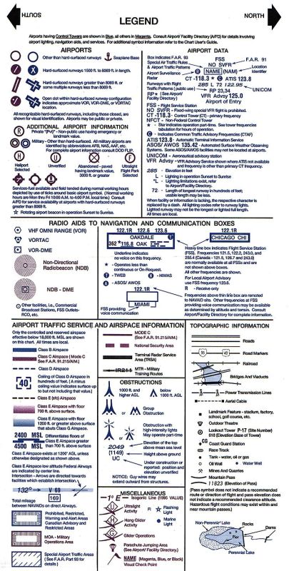
Flightmaps of the area and charts of some airports.
Unfortunatelly I have no idea what most of the Symbols mean. Could someone point me to a tutorial ?
Haven
NFo/Simviation Multiplayer Server.

fs.netfrag.org:23456

Stats: fs.netfrag.org
Teamspeak: ts.netfrag.org
User avatar
-sam-
Captain
Captain
 
Posts: 590
Joined: Thu Sep 09, 2004 10:03 am
Location: EDDM

Re: Flight Maps/Charts Descriptions ?

Postby wji » Fri Jul 15, 2005 10:14 am

FS9/CHARTS folder
C:\Program Files\Microsoft Games\Flight Simulator 9\Charts\legend.jpg
or ONLINE

Image
FS9/CHARTS folder legend.jpg
Image PhotoShop 7 user
User avatar
wji
Major
Major
 
Posts: 1644
Joined: Tue May 04, 2004 11:27 am

Re: Flight Maps/Charts Descriptions ?

Postby -sam- » Fri Jul 15, 2005 10:31 am

oh..  looks like I should pay more attention to the fs9 help and lessons !! Thank You very much !!
NFo/Simviation Multiplayer Server.

fs.netfrag.org:23456

Stats: fs.netfrag.org
Teamspeak: ts.netfrag.org
User avatar
-sam-
Captain
Captain
 
Posts: 590
Joined: Thu Sep 09, 2004 10:03 am
Location: EDDM


Return to FS 2004 - A Century of Flight

Who is online

Users browsing this forum: No registered users and 332 guests