Creating Waypoints o the ground

Forum dedicated to Microsoft FS2004 - "A Century of Flight".

Creating Waypoints o the ground

Postby Lurch16th » Sun Jan 30, 2005 1:38 pm

Is there a way to make a flight plan and/or create waypoints anywhere on the ground, using lat/long coordinates?

ie, if i wanted to fly to a particular mountaintop or bridge(not a VOR,airport or other nav aid)
Lurch16th
Ground hog
Ground hog
 
Posts: 38
Joined: Sat Jan 08, 2005 8:52 pm

Re: Creating Waypoints o the ground

Postby Brute » Sun Jan 30, 2005 9:21 pm

NO


sry :(
Future pilot...so you can scream to god, he cant hear you
User avatar
Brute
2nd Lieutenant
2nd Lieutenant
 
Posts: 128
Joined: Thu Sep 16, 2004 6:24 pm

Re: Creating Waypoints o the ground

Postby Gypsy_Baron » Mon Jan 31, 2005 3:43 pm

Is there a way to make a flight plan and/or create waypoints anywhere on the ground, using lat/long coordinates?

ie, if i wanted to fly to a particular mountaintop or bridge(not a VOR,airport or other nav aid)


Well that depends.
Last night I was flying the B707-420 by George Carty with
his panel. It has an INS nav system that can be programmed
with Lat/Lon coordinates, up to 25 waypoints.
You can program the waypoints on the ground or in the air.
I believe you can even pre-program the flight plan by
creating/editing a .dat file that can be loaded into the
INS system.
I don't know if this INS gauge can be used in other panels
or aircraft but in that pane it can do what you are looking for.

   Paul
Image
User avatar
Gypsy_Baron
1st Lieutenant
1st Lieutenant
 
Posts: 467
Joined: Tue Oct 05, 2004 6:33 pm
Location: Daly City, California

Re: Creating Waypoints o the ground

Postby MattNW » Mon Jan 31, 2005 5:06 pm

Not possible in the default FS setup unless like Gypsy_Baron said, the aircraft designer has made a FC capable of accepting Lat/Lon coordinates. If you just have to have this capability then you can buy (yes it's payware but worth it in my opinion) FSNavigator. It will give you this along with a pretty powerful flight planning capability.
Last edited by MattNW on Mon Jan 31, 2005 5:07 pm, edited 1 time in total.
In Memory of John Consterdine (FS Tipster)1962-2003
User avatar
MattNW
Major
Major
 
Posts: 1705
Joined: Tue Mar 25, 2003 2:34 pm
Location: Indiana

Re: Creating Waypoints o the ground

Postby RollerBall » Mon Jan 31, 2005 5:57 pm

:)

Ahhh....no, you can do it and it's quite easy too. You do it by editing your saved flightplan which is in a folder called flight simulator files in My Documents. Just use Notepad or Wordpad.

Here's a little flightplan to fly from Luton to Lydd IFR low altitude taking the 'scenic' route via various VORs.

[flightplan]
AppVersion=9.1.40901
title=EGGW to EGMD
description=EGGW, EGMD
type=IFR
routetype=2
cruising_altitude=3500
departure_id=EGGW, N51* 52.80', W0* 22.69', +000525.99
departure_position=GATE 7
destination_id=EGMD, N50* 57.69', E0* 56.68', +000011.99
departure_name=Luton
destination_name=Lydd
waypoint.0=, EGGW, , EGGW, A, N51* 52.80', W0* 22.69', +000525.99,
waypoint.1=EG, BPK, , BPK, V, N51* 44.98', W0* 6.40', +000381.99,
waypoint.2=EG, BIG, , BIG, V, N51* 19.85', E0* 2.09', +000590.00,
waypoint.3=EG, MAY, , MAY, V, N51* 1.03', E0* 6.97', +000200.00,
waypoint.4=, EGMD, , EGMD, A, N50* 57.69', E0* 56.68', +000011.99,

I then decide that after Biggin, instead of flying direct to Mayfield, I'll fly overhead West Malling (now a housing estate, once one of the most famous Battle of Britain airfields).

So I modify my flightplan, using Notepad, and add an extra waypoint. Note I change the waypoint numbering and create a code WSTM for the waypoint.

[flightplan]
AppVersion=9.1.40901
title=EGGW to EGMD
description=EGGW, EGMD
type=IFR
routetype=2
cruising_altitude=3500
departure_id=EGGW, N51* 52.80', W0* 22.69', +000525.99
departure_position=GATE 7
destination_id=EGMD, N50* 57.69', E0* 56.68', +000011.99
departure_name=Luton
destination_name=Lydd
waypoint.0=, EGGW, , EGGW, A, N51* 52.80', W0* 22.69', +000525.99,
waypoint.1=EG, BPK, , BPK, V, N51* 44.98', W0* 6.40', +000381.99,
waypoint.2=EG, BIG, , BIG, V, N51* 19.85', E0* 2.09', +000590.00,
waypoint.3=EG, WSTM, ,WSTM, I, N51* 16.0', E0* 24.00', +000000.00, A56
waypoint.4=EG, MAY, , MAY, V, N51* 1.03', E0* 6.97', +000200.00,
waypoint.5=, EGMD, , EGMD, A, N50* 57.69', E0* 56.68', +000011.99,

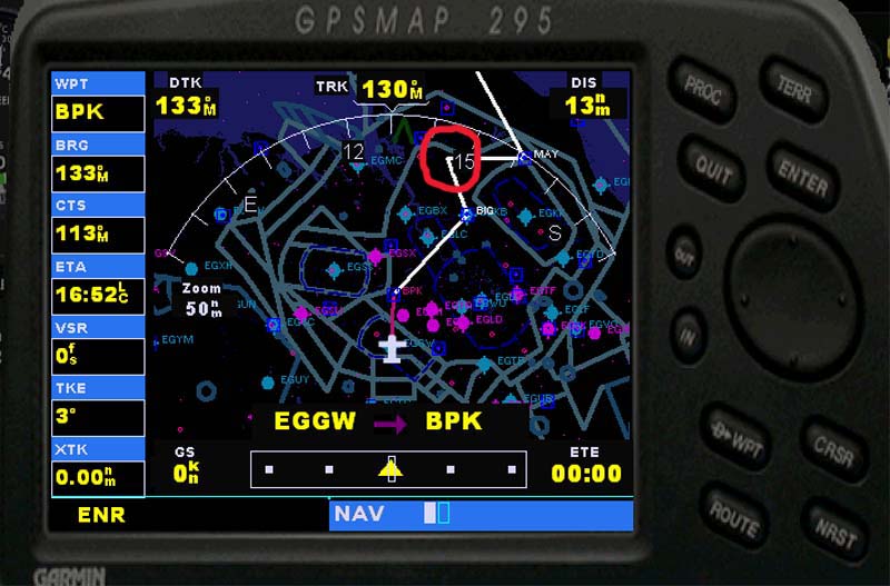
The flightplan was quite happily accepted by ATC - so you will have no problem with a VFR one. Here's a pic of the GPS and I've ringed the new waypoint in red.

Image

The flight goes fine according to plan. Here I'm turning over West Malling which is just a large open space in FS2004.

Image

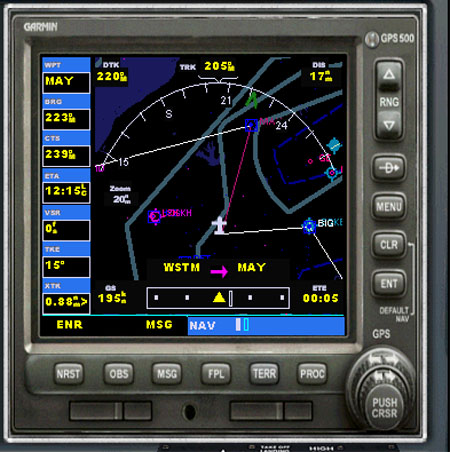
My Navajo has a Garmin 500 and here you can see that the 'false' waypoint shows up fine - the leg is WSTM to Mayfield after the turn.

Image

I had to cancel my flightplan and just fly on the GPS because ATC wanted to vector me into Lydd and take me off my planned track but all went OK.

In the modified plan I've set the new waypoint as an Intersection (I).

Intersections have all the zeros at the end of the line and for this plan I put in a 3 digit code (A56) that looked right for intersections from other plans in that area. I don't know what it means and you may well be able to leave it out. Try experimenting, but as you can see the principle works fine.
;)

PS - I just took the A56 out. The plan was accepted and I can see no reason why it shouldn't fly fine.

So that makes it dead easy. FSNavigator indeed...you guys will never learn :)
Last edited by RollerBall on Mon Jan 31, 2005 6:19 pm, edited 1 time in total.
RollerBall
 

Re: Creating Waypoints o the ground

Postby Lurch16th » Mon Jan 31, 2005 7:46 pm

Hey Rollerball,

this is exactly what i tried to do, diddle with the MSFS *.pln file.  But i couldn't get it to show the waypoint in the flight planner.

But i should clarify,  or maybe re-phrase question;
When i state show up on the ground, i mean when you look out through any of the windows, can you see any of the msfs waypoints sitting on the ground?

Sort of like you would looking through a HUD in a warplane.

When i had no luck with the pln file, i downloaded the FS Navigator and managed to create my own waypoints.

But still couldn't see them sitting on the ground.

So, do they only show up on the GPS or kneeboard maps?

I couldn't see any on your screen shot of the plane's exterior view.
Lurch16th
Ground hog
Ground hog
 
Posts: 38
Joined: Sat Jan 08, 2005 8:52 pm

Re: Creating Waypoints o the ground

Postby RollerBall » Mon Jan 31, 2005 7:53 pm

:)

Do they show up on the ground in real life?

Remember ....... this is as real as it gets  ;)
RollerBall
 

Re: Creating Waypoints o the ground

Postby MattNW » Tue Feb 01, 2005 7:35 pm

That's one on me. Never knew that trick.

Oh well, I keep on a learnin'.
In Memory of John Consterdine (FS Tipster)1962-2003
User avatar
MattNW
Major
Major
 
Posts: 1705
Joined: Tue Mar 25, 2003 2:34 pm
Location: Indiana


Return to FS 2004 - A Century of Flight

Who is online

Users browsing this forum: No registered users and 764 guests