FSX Must Sees!!!!
Mount Rushmore
http://i283.photobucket.com/albums/kk28 ... shmore.jpg
Mount Rushmore National Memorial is a granite mountain sculpture of four american presidents located in South Dakota, United States.
Takeoff from Custer Co (KCUT) and fly heading 011 for 9 nm. The sculpture may be a bit difficult to locate so alternatively locate it using the coordinates N43*52.13' W103*32.38 (press Shift+Z) or 23.7 nm from VOR 112.3 on radial 243.
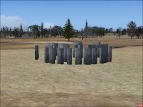
Stone Henge
http://i283.photobucket.com/albums/kk28 ... ehenge.jpg
Stonehenge is an old monument of stones in the southern United Kingdom.
The monument is small and hence difficult to locate from the air. If you don't find it, set autogen density to none in the display settings.
VFR: Takeoff from runway 35 at Boscombe Down (EGDM) and fly runway heading. When reaching a major road, follow the road to the west. At a certain point, the road becomes narrower and splits into two smaller roads. At this point, the monument will be visible when you look straight ahead (to the west).
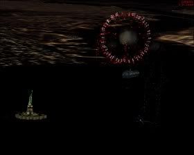
Fireworks
http://i283.photobucket.com/albums/kk28 ... eworks.jpg
New Year
Fly over one of the major cities just when the year changes.
Independence Day
The 4th of July is the American national holiday, Independence Day. There is fireworks at least in New York City, Washington, D.C., and Las Vegas from 22.00.
Bastille Day
The 14th of July is the French national holiday, Bastille Day. There is fireworks at least in Paris close to the Eiffel Tower from 22.00.
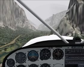
Yosemite Valley
http://i283.photobucket.com/albums/kk28 ... valley.jpg
Yosemite Valley is a famous valley in the Sierra Nevada mountain range of California, United States. The 11 km long and ~1.5 km wide valley is located at 4000' ASL surrounded by 3000'-4000' high cliffs.
Takeoff from Mariposa-Yosemite Airport (O68) in a light aircraft. Maybe you need to gain some altitude to the west before you turn northeast and head for the valley which starts at N37* 43.40' W119* 38.80' (map). At the end of the valley you'll see the Half Dome at N37* 44.76' W119* 31.99'. If you follow the valley at low altitude in a light aircraft you'll need to do a 180
http://i283.photobucket.com/albums/kk28 ... shmore.jpg
Mount Rushmore National Memorial is a granite mountain sculpture of four american presidents located in South Dakota, United States.
Takeoff from Custer Co (KCUT) and fly heading 011 for 9 nm. The sculpture may be a bit difficult to locate so alternatively locate it using the coordinates N43*52.13' W103*32.38 (press Shift+Z) or 23.7 nm from VOR 112.3 on radial 243.
Stone Henge
http://i283.photobucket.com/albums/kk28 ... ehenge.jpg
Stonehenge is an old monument of stones in the southern United Kingdom.
The monument is small and hence difficult to locate from the air. If you don't find it, set autogen density to none in the display settings.
VFR: Takeoff from runway 35 at Boscombe Down (EGDM) and fly runway heading. When reaching a major road, follow the road to the west. At a certain point, the road becomes narrower and splits into two smaller roads. At this point, the monument will be visible when you look straight ahead (to the west).
Fireworks
http://i283.photobucket.com/albums/kk28 ... eworks.jpg
New Year
Fly over one of the major cities just when the year changes.
Independence Day
The 4th of July is the American national holiday, Independence Day. There is fireworks at least in New York City, Washington, D.C., and Las Vegas from 22.00.
Bastille Day
The 14th of July is the French national holiday, Bastille Day. There is fireworks at least in Paris close to the Eiffel Tower from 22.00.
Yosemite Valley
http://i283.photobucket.com/albums/kk28 ... valley.jpg
Yosemite Valley is a famous valley in the Sierra Nevada mountain range of California, United States. The 11 km long and ~1.5 km wide valley is located at 4000' ASL surrounded by 3000'-4000' high cliffs.
Takeoff from Mariposa-Yosemite Airport (O68) in a light aircraft. Maybe you need to gain some altitude to the west before you turn northeast and head for the valley which starts at N37* 43.40' W119* 38.80' (map). At the end of the valley you'll see the Half Dome at N37* 44.76' W119* 31.99'. If you follow the valley at low altitude in a light aircraft you'll need to do a 180
 That really brings out the good in fsx 8-)
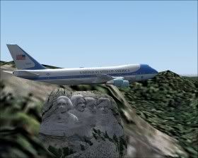