Alrighty, we'll start on the left side of the bottom portion:

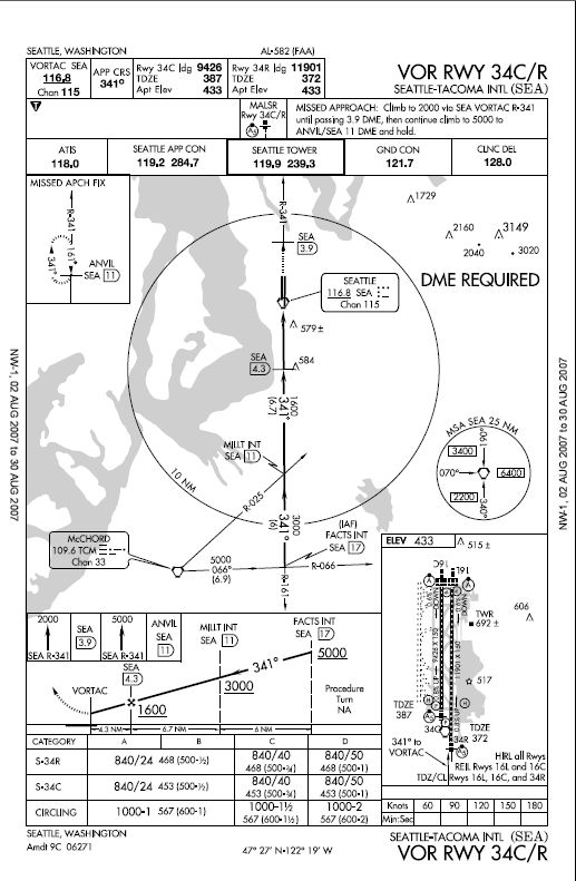
This section is the graphic missed approach section. It shows the published missed approach procedure that's written at the top, but in a graphic form that's a bit easier to read. This particular one shows that the missed approach procedure is to climb to 2000 ft via the 341 degree radial from the Seattle VORTAC, then at 3.9 miles from the VORTAC, continue the climb to 5000 and fly to ANVIL intersection and enter the published hold.
___________________________________________________________________________

This section shows the profile (side) view of the approach. It shows the approach beginning at FACTS intersection, or 17 miles from the Seattle VORTAC at 5000 ft MSL. Once you cross FACTS intersection, and you are on-course on a 341 degree course, you can descend down to 3000 ft. Once you reach MILLT intersection at 11 miles on the DME, you can descend down to 1600 ft. Once you reach the final approach fix (maltese cross), 4.3 miles from the Seattle VORTAC, you can descend down to your MDA, which is different depending on what you are flying, and what type of approach you will be making.
___________________________________________________________________________

This section shows your MDAs for the different categories of aircraft, and the different types of approaches. You figure out what category your aircraft is by multiplying the V
SO at maximum landing weight by 1.3, and if its from 0-90 kts, you are category A, 91-120 kts, cat. B, 121-141 kts, cat. C, 141-164 kts, cat D., and above 165 kts, cat. E. This section also shows the MDAs for the different types of approaches. This particular plate has MDAs for the straight-in 34R approach, the straight-in 34C approach, and the circling approach. The MDAs are shown as MSL altitudes, followed by a required visibility either as RVR or visibility in statute miles. RVR of is in feet, so 24 is 2400 feet, which is one half statute mile visibility. So, for example, the MDA for the straight-in approach to runway 34R for a category C aircraft would be 840/40, or 840 ft MSL, and an RVR visibility of 40, or approx. 3/4 miles.
___________________________________________________________________________

This is just a plan view of the airport that shows the runway layouts, lighting, touchdown zone altitudes, as well as a few other things.
___________________________________________________________________________

This is where the timing for the missed approach point (MAP) would be, but for this particular approach, a DME is required and must be used to identify the MAP, so the timing is not used. If it were used, it would be the time from the final approach fix to the MAP.
___________________________________________________________________________

This section shows the minimum safe altitudes (MSA) out to 25 nm from the Seattle VORTAC. It shows particular radials that define various sectors of the area, and the MSA in each sector. This section should only be used for emergencies. If you need a minimum altitude in this area, the off-route obstruction clearance altitude (OROCA) on the enroute chart, the departure procedures for the airport found in the front of the approach plate book, or RADAR vectors from ATC should be used.


 That last step-down fix is a DME distance from the VORTAC, no the VORTAC itself. I'll fix it, thanks Brett.