Page 1 of 1

Please help me

PostPosted: Thu Jun 12, 2014 1:35 pm
by manuel2715
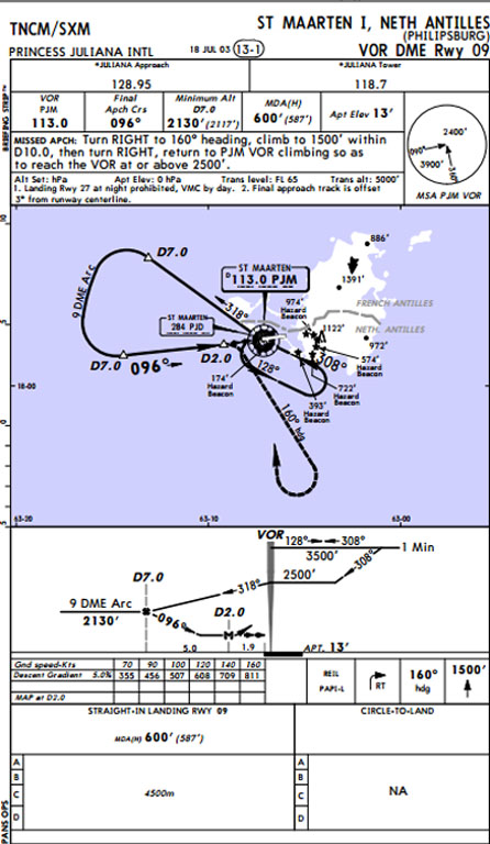
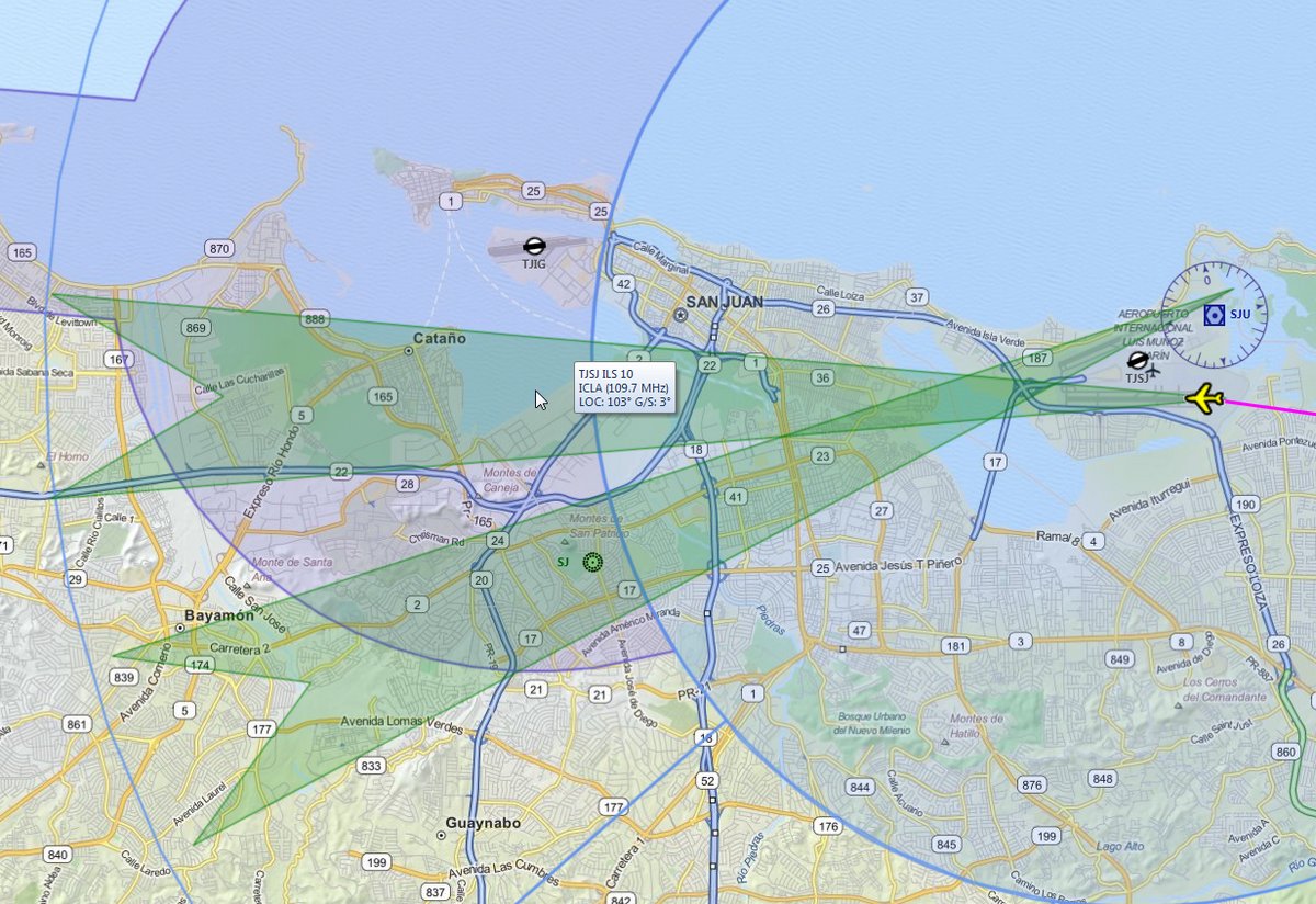
Hi. I am using flight simulator x. Today i tried to fly from San Juan PR (TJSJ) to St.Marteen TNCM. When I am preparing for my flight I have to put in the radio stack
the frequency for an ILS approach the frequency is 118.70 but it only goes to 117.70. I am using a Bombardier CRJ700. What can i do? Thanks... <<r

Re: Please help me

PostPosted: Thu Jun 12, 2014 2:14 pm
by dave3cu
Recheck your airport information.....

118.70 is the Control Tower frequency. There are no ILS approaches to TNCM

Re: Please help me

PostPosted: Thu Jun 12, 2014 2:48 pm
by manuel2715
so i guess i have to go visual

Re: Please help me

PostPosted: Thu Jun 12, 2014 4:06 pm
by Fozzer
As Dave says...

Runway 9/27

118.70 Tower Frequency.
128.95 Approach Frequency.

113.00 VOR
308.0 NDB.
284.0 NDB.

No ATIS.

Via FS Tramp...>>> http://www.fstramp.com/


Paul.... :mrgreen: ...!

Re: Please help me

PostPosted: Thu Jun 12, 2014 5:38 pm
by OldAirmail
You gota watch out for Paul, Manuel.

He's the largest stockholder of FSTramp International. :D

Not only that, but he gets a $100 kickback for each referral to FSTramp. :lol:


As you probably know, there are many sources for charts and air navigation information.

JeppView : TNCM, AirNav, and more.

If you want to become a real pilot, those would be the best way to gain the info. Especially the Jeppesen charts.


But just for fun (and free), there's an alternative called Plan-G

These are from Plan-G

St. Maarten
Image

St. Maarten close up
Image


These maps provide info when you hover over certain parts, or right click on certain parts, of the map

Image


Image

BTW - Welcome to the club.

Re: Please help me

PostPosted: Thu Jun 12, 2014 6:40 pm
by manuel2715
thanks a lot OldAirmail

Re: Please help me

PostPosted: Thu Jun 12, 2014 9:08 pm
by OldAirmail
It's nothing.

Plan-G, and FSTramp, have a lot of features built in. It may take some time to learn, but you don't have to learn it all at once to be able to use it.


But tell us - What plane were you going to fly to St Maarten in?

When I flew into San Juan on Saturday I used a Howard 500.

Image

Image

Re: Please help me

PostPosted: Fri Jun 13, 2014 1:13 am
by manuel2715
I was using the bombardier crj700

Re: Please help me

PostPosted: Fri Jun 13, 2014 3:45 am
by Fozzer
For anyone who is really interested in using Radio Navigation, "FS Tramp" and "Plan-G" are highly recommended, even if only the (Radar) Map function is used to obtain all the Airfield frequencies, and the Radio Beacon, VOR, NDB, etc, frequencies.

Also; its use as a "Radar Map" to observe the locations of other Pilots, when connected to Multiplayer, is invaluable!

...and what is even better....both programs are...."FREE".... :dance: ...!

You will have ALL the radio frequencies at your fingertips...and you will never get lost!

Install one, or both, you'll not regret it!

Paul.....G-BPLF Multiplayer.... 8-) ....!

Re: Please help me

PostPosted: Tue Jun 17, 2014 5:04 pm
by FoMoCo63
Another option I use, would be the AIP for the Procedure into TNCM (see example below) this will show you how to land ( MSA, traffic, correct headings, when to start decent, decision hgt., missed approach ) without using an ILS Approach. Real World navigational charts like these are free on the internet.

Image

Re: Please help me

PostPosted: Fri May 14, 2021 9:43 am
by TyraNoah
Hello every one, i am aspiring to join an aviation school.
any ADVISE on the best school.
any where in Europe.
<<r

Re: Please help me

PostPosted: Fri May 14, 2021 10:44 am
by cevans
TyraNoah wrote:Hello every one, i am aspiring to join an aviation school.
any ADVISE on the best school.
any where in Europe.
<<r


ANYWHERE? Are you for real? :D
You can learn to fly at 1000'sschools. Where are you and what do you want to learn to fly for?

Re: Please help me

PostPosted: Fri May 21, 2021 6:08 am
by KayBur
Fozzer wrote:For anyone who is really interested in using Radio Navigation, "FS Tramp" and "Plan-G" are highly recommended, even if only the (Radar) Map function is used to obtain all the Airfield frequencies, and the Radio Beacon, VOR, NDB, etc, frequencies.

Also; its use as a "Radar Map" to observe the locations of other Pilots, when connected to Multiplayer, is invaluable!

...and what is even better....both programs are...."FREE".... :dance: ...!

You will have ALL the radio frequencies at your fingertips...and you will never get lost!

Install one, or both, you'll not regret it!

Paul.....G-BPLF Multiplayer.... 8-) ....!


Great recommendation. It's really handy! It's better to have all the software you need right away.

Re: Please help me

PostPosted: Tue Feb 07, 2023 6:28 am
by tonii9
Even if merely the (Radar) Map feature is utilised to gather all the Airfield frequencies, as well as the Radio Beacon, VOR, NDB, etc. frequencies, "FS Tramp" and "Plan-G" are strongly advised for anybody who is seriously interested in utilising Radio Navigation.

Re: Please help me

PostPosted: Fri Mar 01, 2024 4:34 pm
by hertzie
Thanks Fozzer!

I still learn every day!

hertzie.