Page 1 of 1

HELP needed with VOR navigation!

PostPosted: Fri Aug 03, 2007 1:14 am
by Stratos
Ok I got it for the most part, I can fly directly TO and FROM a VOR station now, but can't understand a thing about selecting other radials to fly.
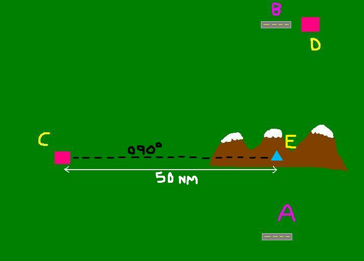
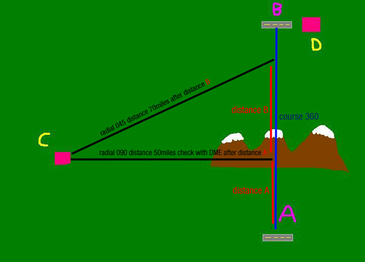
I made a little paint to ask a question:

Image

I'm in airfield A ( bottom of the map ) I can select VOR C in the EAST, but I'm too far to select VOR D ( Airfield B ) how can I navigate from A to B using VOR C??
Sure I can choose to fly directly to C, and then directly to D, but there's no another way that don't need to fly over C??

Thank's and hope you apreciatte my artistic sense

Re: HELP needed with VOR navigation!

PostPosted: Fri Aug 03, 2007 3:32 am
by john_uk
get a rough heading for A - B climb over the hills, on that heading and you should pick up the signal

Re: HELP needed with VOR navigation!

PostPosted: Fri Aug 03, 2007 4:47 am
by BFMF
VORs can be very usefull when triangulating your position. If you wanted to fly over the mountains, you could find and fly a heading from Airport A to Airport B/VOR D, and triangulate your position with VOR C untill your radios can pick up VOR D.

Re: HELP needed with VOR navigation!

PostPosted: Fri Aug 03, 2007 4:59 am
by EGNX
Well in this situation VOR 'C' can't really be used, unless you want to fly direct to VOR 'C' and then direct to VOR 'D' which would make the journey longer than what it need be. You could however create a sort of intersection using VOR 'C' as long as it was equipt with DME. Simply tune into VOR 'C' and select 090o inbound radial, now before you fly you should have a look at the map and measure the distance from point 'E' (Which I have drawn on the map, 50 nm or so) So when you take-off from Airfield 'A' head due north and keep monitoring the DME and VOR Needle in the cockpit (If you want to make it easier simply use your map to work out the distance from intersection 'E' to Airfield 'A' and then you can roughly work out how long it will take you to arrive at the intersection using, Time = Distance divided by Speed.) So when you near the intersection your DME should (If you've stayed roughly on course) read around 50nm as the VOR needle become centered. So you know know where you are (and thats Intersection 'E'!) So hopefully by now you could tune into VOR 'D' and make it to Airfield 'B'.

Image

Another method would be simply fly it VFR. You know the Airfield 'B' is pretty much north of Airfield 'A'. So just fly north, and have a look at a map before and when your flying to keep a check on where abouts you are, and compensate for any wind or other factors effecting your course.

Or easiest way of all.... GPS

Re: HELP needed with VOR navigation!

PostPosted: Fri Aug 03, 2007 5:34 am
by -sam-
edit: EGNX was faster :)

Image

(distances an radials are ficional)

you would draw several lines from VOR C to your course (360

Re: HELP needed with VOR navigation!

PostPosted: Fri Aug 03, 2007 7:01 am
by Brett_Henderson
Edit: This is just a long-winded version of Esselbach's

Re: HELP needed with VOR navigation!

PostPosted: Fri Aug 03, 2007 7:25 am
by TSC.
Well I think you guys have got all the bases covered here, so I'll just mention that you need to be careful in those mountains - the one in the middle seems to be getting increasingly larger.  :o

;D

TSC.

Re: HELP needed with VOR navigation!

PostPosted: Fri Aug 03, 2007 8:24 am
by Stratos
All the response are logical, clear and usable in different situations.
But imagine the mountains are high, and you Cessna can't climb it, so you need to go west and avoid the snow capped self growing mountains  ;)

So I tought that:

Image

Fly to C in the Radial 120 and TO the station, and then, once we cleared the mountains safely, pick radial 70 FROM the station and fly it until I can pick a radial of D.
The problem is:

-Can this be done?
and HOW??

How I know is time to change the radial 120 TO for the radial 70 FROM??

That's it

Re: HELP needed with VOR navigation!

PostPosted: Fri Aug 03, 2007 8:36 am
by BFMF
The default Cessna 172(This applied to FS9, so i'm assuming it also applies to FSX) has two navigational radios. Have Nav1 radio tuned to VOR C and set to the XXX degree radial. Set Nav2 radio to VOR D, and also on the YYY degree radial.

Take off, and fly towards VOR C on the XXX degree radial while watching your Nav2 radio. When the Nav2 dial centers, you have intercepted the YYY radial to VOR D. Now you just need to follow that radial to VOR D

Re: HELP needed with VOR navigation!

PostPosted: Fri Aug 03, 2007 8:37 am
by EGNX
[quote]All the response are logical, clear and usable in different situations.
But imagine the mountains are high, and you Cessna can't climb it, so you need to go west and avoid the snow capped self growing mountains

Re: HELP needed with VOR navigation!

PostPosted: Fri Aug 03, 2007 6:42 pm
by macca22au
And with the DME it is accurate.

Fly to a required DME distance on the TO radial

Re: HELP needed with VOR navigation!

PostPosted: Sun Aug 12, 2007 12:24 am
by diga
Hi Everybody!

If you wants to learn Navigation the best site is:

www.navfltsm.addr.com/

Really very good site and I learned lot. Try it.

Re: HELP needed with VOR navigation!

PostPosted: Sun Aug 12, 2007 5:23 am
by macca22au
Diga: that's a great site and I would recommend it to anyone interested in learning radio navigation.  Thanks.

It reminds us that for other than stick and rudder circuits around afreshly mowed field study is needed.  In fact a pilot's licence to carry passengers cross-country is hard to get, and a huge responsibility.

Navigation ain't easy.  But its fun to learn.

Why? it can be CAVOK when you take off, become deceptively cloudy as you go on, check points may not be identified, or the wind my be in a direction or strength different to what you planned, and suddenly you need to know where you are and the direcion to go to get to your destination.

The old NDB the bird dog is still good because it always points to the station, but the VOR/DME is highly precise and you can do really complex navigation with it.  And FS is a good medium in which to learn to use it.  There is nothing more useful than the Pause key. or even to reset a flight.  You can't do that in the real world.