Page 1 of 1

You've got to try this!

PostPosted: Thu Sep 22, 2005 12:12 am
by Wing Nut
Load any flight plan file into this and see it on Google Earth!  This rules!

http://codexweb.atomictag.com/fplan.aspx

Re: You've got to try this!

PostPosted: Thu Sep 22, 2005 1:53 pm
by Fly2e
Kevin, there is something similar to this at Avsim today.
Worth a check out?


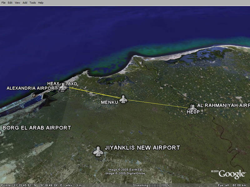
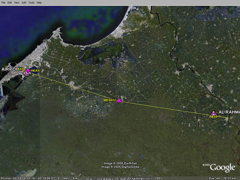
Flips 1.1 - view flightplans in Google Earth      

File Description:
Flips is a small utility to view FS9 flightplans in Google Earth. View your entire flightplan in 3D and make sure your chosen waypoints don't let you miss exiting landmarks along your flight. Updated version 1.1 now supports 3 variations in FS9 flightplan formats and should fix a couple of read errors. More drawing options, improved help and sample flightplans included.


Filename: flips11.zip
License: Freeware
Added: 21st September 2005
Downloads: 1368
Author: Michael Rook
Size: 1028kb

Re: You've got to try this!

PostPosted: Fri Sep 23, 2005 2:24 am
by Carlo
Cool thing, Kevin. Fly2e, I noticed the file on AvSim too. Wonder if it does the same.

Screenshot of Kevin's link:

Image

Screenshot of Fly2e's suggestion:

Image

Clearly there is a small difference. Flips is also a little harder to use.

Crash ;)

P.S. I hope you don't mind I used two screenshot for clearing things up.

C.

Re: You've got to try this!

PostPosted: Fri Sep 23, 2005 6:08 am
by pete

Re: You've got to try this!

PostPosted: Fri Sep 23, 2005 6:53 am
by Carlo
Thanks for giving the link, Pete.

Crash ;)

Re: You've got to try this!

PostPosted: Fri Sep 23, 2005 8:31 am
by chief1995
Stupid Question ; how do you view google earth, afer you are in flight?
Do you have to pause to see it? I am confused on how to use, what looks like a good addition to flight sim.

Thanks,

Chief

Re: You've got to try this!

PostPosted: Fri Sep 23, 2005 10:09 am
by Carlo
Hi chief,

For all it's worth it is working without FS. You create a flightplan in FS. After you safe that, you can open it in either of both programs mentioned above. If you want to see it while flying, you have to pause the simulator.

Crash ;)

Re: You've got to try this!

PostPosted: Fri Sep 23, 2005 10:16 am
by wji
Thanks, Pete, et al . . . charts (any charts) rule!

Re: You've got to try this!

PostPosted: Fri Sep 23, 2005 12:01 pm
by chief1995
Thanks Sir Crashalot, I suspected that was the case!

Regards,

Chief

Re: You've got to try this!

PostPosted: Sun Sep 25, 2005 8:58 am
by Tweek
Would be a great VFR tool, as you can see what the land is supposed to look like around you (rivers, towns etc) I may have to download it :)

Re: You've got to try this!

PostPosted: Sun Sep 25, 2005 9:01 am
by legoalex2000
i was gonna say, someone had to have notices (ie: me) that that extension was here on Simv since i think wed. or thurs.

:)Ramos

Re: You've got to try this!

PostPosted: Fri Sep 30, 2005 5:23 am
by indialimaalpha
Hi all,
I'm the author of the http://codexweb.atomictag.com/fplan.aspx page...

Thanks a lot for your kind words !!!

Now, as I see that you're interested in this Google Earth/FS2004 thing, maybe you'll like also another tool (not mine, this time): it's name is myFsGoogleEarth, and you can find all the info here:
http://www.elbiah.de/flusi/MyFsGoogleEarth/MyFsGoogleEarth.htm

You'll like it very much, guaranteed !

Re: You've got to try this!

PostPosted: Fri Sep 30, 2005 12:31 pm
by Alphajet_Enthusiast
I read about this in the latest edition of PCPilot.... seems like a very cool tool!  :)