Ahhh....no, you can do it and it's quite easy too. You do it by editing your saved flightplan which is in a folder called flight simulator files in My Documents. Just use Notepad or Wordpad.
Here's a little flightplan to fly from Luton to Lydd IFR low altitude taking the 'scenic' route via various VORs.
[flightplan]
AppVersion=9.1.40901
title=EGGW to EGMD
description=EGGW, EGMD
type=IFR
routetype=2
cruising_altitude=3500
departure_id=EGGW, N51* 52.80', W0* 22.69', +000525.99
departure_position=GATE 7
destination_id=EGMD, N50* 57.69', E0* 56.68', +000011.99
departure_name=Luton
destination_name=Lydd
waypoint.0=, EGGW, , EGGW, A, N51* 52.80', W0* 22.69', +000525.99,
waypoint.1=EG, BPK, , BPK, V, N51* 44.98', W0* 6.40', +000381.99,
waypoint.2=EG, BIG, , BIG, V, N51* 19.85', E0* 2.09', +000590.00,
waypoint.3=EG, MAY, , MAY, V, N51* 1.03', E0* 6.97', +000200.00,
waypoint.4=, EGMD, , EGMD, A, N50* 57.69', E0* 56.68', +000011.99,
I then decide that after Biggin, instead of flying direct to Mayfield, I'll fly overhead West Malling (now a housing estate, once one of the most famous Battle of Britain airfields).
So I modify my flightplan, using Notepad, and add an extra waypoint. Note I change the waypoint numbering and create a code WSTM for the waypoint.
[flightplan]
AppVersion=9.1.40901
title=EGGW to EGMD
description=EGGW, EGMD
type=IFR
routetype=2
cruising_altitude=3500
departure_id=EGGW, N51* 52.80', W0* 22.69', +000525.99
departure_position=GATE 7
destination_id=EGMD, N50* 57.69', E0* 56.68', +000011.99
departure_name=Luton
destination_name=Lydd
waypoint.0=, EGGW, , EGGW, A, N51* 52.80', W0* 22.69', +000525.99,
waypoint.1=EG, BPK, , BPK, V, N51* 44.98', W0* 6.40', +000381.99,
waypoint.2=EG, BIG, , BIG, V, N51* 19.85', E0* 2.09', +000590.00,
waypoint.3=EG, WSTM, ,WSTM, I, N51* 16.0', E0* 24.00', +000000.00, A56
waypoint.4=EG, MAY, , MAY, V, N51* 1.03', E0* 6.97', +000200.00,
waypoint.5=, EGMD, , EGMD, A, N50* 57.69', E0* 56.68', +000011.99,
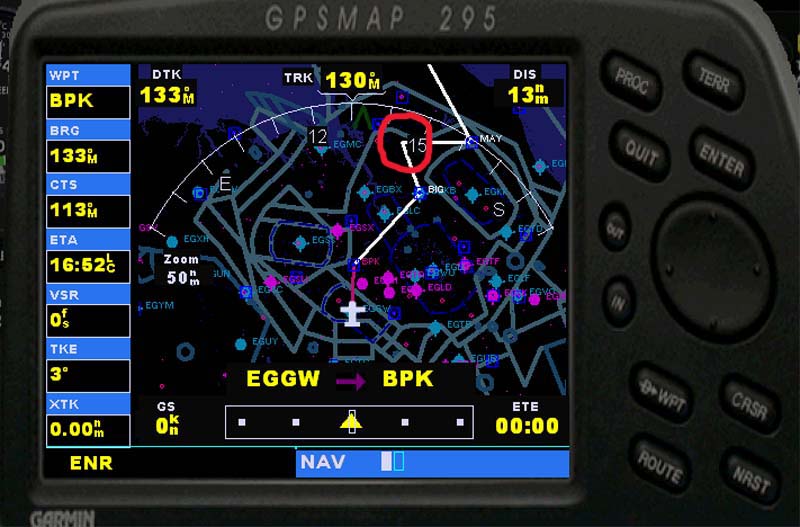
The flightplan was quite happily accepted by ATC - so you will have no problem with a VFR one. Here's a pic of the GPS and I've ringed the new waypoint in red.

The flight goes fine according to plan. Here I'm turning over West Malling which is just a large open space in FS2004.

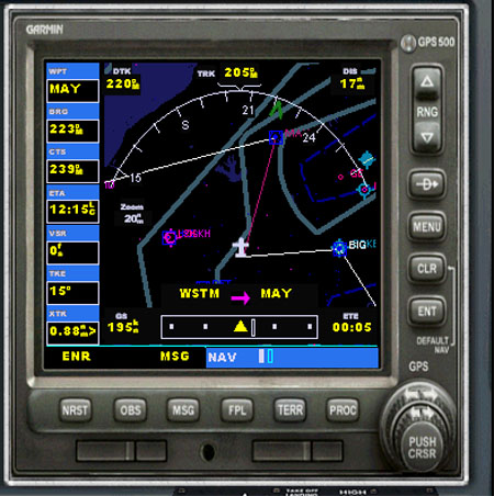
My Navajo has a Garmin 500 and here you can see that the 'false' waypoint shows up fine - the leg is WSTM to Mayfield after the turn.

I had to cancel my flightplan and just fly on the GPS because ATC wanted to vector me into Lydd and take me off my planned track but all went OK.
In the modified plan I've set the new waypoint as an Intersection (I).
Intersections have all the zeros at the end of the line and for this plan I put in a 3 digit code (A56) that looked right for intersections from other plans in that area. I don't know what it means and you may well be able to leave it out. Try experimenting, but as you can see the principle works fine.

PS - I just took the A56 out. The plan was accepted and I can see no reason why it shouldn't fly fine.
So that makes it dead easy. FSNavigator indeed...you guys will never learn


