Adding bushstrips

Forum dedicated to Microsoft FS2004 - "A Century of Flight".

Adding bushstrips

Postby pedalspete » Mon Sep 06, 2004 8:15 am

Hey everyone, hope you're all having a good day. I've been virtual bush bashing in the far north of Australia and I was wondering if there's some utility which would let me add simple strips or even just a visual point of some type to a specific point of the scenary?
Cheers
Pete.
   
pedalspete
Ground hog
Ground hog
 
Posts: 14
Joined: Tue Aug 31, 2004 6:52 am

Re: Adding bushstrips

Postby BFMF » Mon Sep 06, 2004 8:45 am

Do a search for FSSC (Flight Simulator Scenery Creator) and download it, and it will allow you to create your own airstrips, plus add objects to scenery if you wish ;)

If you got any questions, all the designer gurus hang out in the design boards ;)
BFMF
Colonel
Colonel
 
Posts: 16266
Joined: Mon Feb 25, 2002 6:06 pm
Location: Pacific Northwest

Re: Adding bushstrips

Postby wji » Mon Sep 06, 2004 9:41 am

From AFCAD2 Readme file

AFCAD Version 2.21 - for FS2004
Creating New Airports: (since v.2.1.1)

This version can create a new airport from scratch using the New Airport item under the File menu.

5. What You Will Be Able To Do With Subsequent Releases of AFCAD:
AFCAD is a work in progress. The ability to modify the following elements will be added to subsequent

releases.

Taxiway Signs
The ability to create, delete, move or modify taxiway signs will be added.

Airport structures
The ability to add, delete, or move airport structures will be added.

Exclusions and Flattening
The ability to exclude existing scenery (and Autogen trees etc.) will be added, as well as the ability to create flattening polygons

bill
Image PhotoShop 7 user
User avatar
wji
Major
Major
 
Posts: 1644
Joined: Tue May 04, 2004 11:27 am

Re: Adding bushstrips

Postby pedalspete » Mon Sep 06, 2004 1:51 pm

Thanks guys, that should get me pointed in the right direction.
pedalspete
Ground hog
Ground hog
 
Posts: 14
Joined: Tue Aug 31, 2004 6:52 am

Re: Adding bushstrips

Postby Fozzer » Mon Sep 06, 2004 3:56 pm

I always use Runway Generator, by Chuck Dome....>>>

http://www.simviation.com/fsdesign_scenery4.htm

For simple, instant tarmac, concrete, grass, dirt, runways.
All done with a bit of data entered in a few boxes...
VOILA...your very own grass, etc, runway in the middle of nowhere... ;D...!

Cheers all... ;D..!

Paul.

P.S. Works fine in FS 2000/FS 2002, haven't tried it in FS 2004... ;)
Win 8.1 64-bit. DX11. Advent Tower. Intel i7-3770 3.9 GHz 8-core. 8 GB System RAM. AMD Radeon HD 7700 1GB RAM. DVD ROM. 2 Terra Byte SATA Hard Drive. Philips 17" LCD Monitor. Saitek Cyborg X Fly-5 Joystick. ...and a Briggs and Stratton Petrol Lawn Mower.
User avatar
Fozzer
Colonel
Colonel
 
Posts: 27361
Joined: Thu Jan 31, 2002 3:11 pm
Location: Hereford. England. EGBS.

Re: Adding bushstrips

Postby pedalspete » Wed Sep 08, 2004 4:52 am

Thanks for the tip on Runway Generator Fozzer. It's exactly what I'm after, though unfortunately it didn't work. Either it won't talk to fs2004 or I've done something wrong. When you generate and save a strip, should it be imported into the fs files automatically or do you need to do that manually? I'd love to nail this as I flew up there in Northern Territoy for about 2.5 years and am aware of a steady trickle of guys from New Zealand who go up there to fly for the same operator as I did. They do really good work providing a very safe and reliable, non profit air service to remote aboriginal communities up in Arnhem Land. Because Arnhem Land as flat as a pancake and a lot of the navigation is visual with reference to the coastline, fs 2004 could be used as a fairly acurate visual sim for route familiarisation purposes if only we could throw in the 70 odd little strips serviced up there. Oh well, I'll keep chasing it as I'd really like to help these guys out.
Cheers
Pete.
pedalspete
Ground hog
Ground hog
 
Posts: 14
Joined: Tue Aug 31, 2004 6:52 am

Re: Adding bushstrips

Postby JBaymore » Wed Sep 08, 2004 8:30 am

pedalspete,

Ah... for that kind of use you probably want to get one of the more accurate terrain meshes for your area.  I think FSGenesis has one.... it's payware.... but only about $9.00 US.

Also you could try the freeware airport design program program called Airport.  It is very easy to use.  

best,

.................john
Image ImageIntel i7 960 quad 3.2G LGA 1366, Asus P6X58D Premium, 750W Corsair, 6 gig 1600 DDR3, Spinpoint 1TB 720
User avatar
JBaymore
Global Moderator
Global Moderator
 
Posts: 10020
Joined: Sat May 24, 2003 9:15 am
Location: New Hampshire

Re: Adding bushstrips

Postby RollerBall » Wed Sep 08, 2004 6:22 pm

I messed around for a few hours to see what I could do with the XML SDK. Came up with a nice little scenery using all default objects as you can see. I plonked it somewhere in the Northern Territories at S15 11.47, E135 32.29.
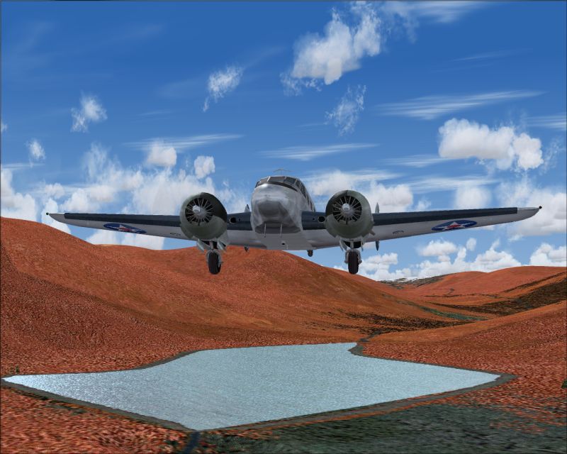
Image

The beauty of this method is that you get your field listed in the Airports list which is quite handy
Image

The scenery contains a 600m dirt runway with markings, Grnd and Tower comms and an NDB, a building with a water tower, a fuel tank and a parked truck which isn't bad for a rough strip.

It's all done with a little XML file that is converted into a bgl file of only 32k. There are no textures to worry about as they are all default objects.

Only one problem - you still need to have an exclude to take out all the trees that would otherwise be all over the runway, and as I did that with Airport, I also put a flatten in as well otherwise you have the old problem of a bouncy runway that can break undercarriages.

So this is one way to do it. You could just use AFCAD if you don't want any buildings or Airport for everything if you want to find and place some suitable macros for things like the truck, building, watertower and so on. That's probably the best way actually as you will need an exclude and flatten for every strip and once you have found suitable objects you can just mix and match and place them at different spots to vary the look of each strip.

That's how I would do it anyway, but obviously you would need to learn a little bit about scenery design to do it successfully.

For anyone interested, here's the XML coding for the scenery.


version="9.0"
xmlns:xsi='http://www.w3.org/2001/XMLSchema-instance'
xsi:noNamespaceSchemaLocation="bglcomp.xsd">

       lat="S15 11.4857"
     lon="E135 32.3248"
     alt="0"
     altitudeIsAgl="TRUE"
     pitch="0"
     bank="0"
     heading="21.2"
     imageComplexity="SPARSE">
                 name="d74829dc41da57eeee6bb4954eb560b8"
           scale="1.1"/>
 

       lat="S15 11.4700"
     lon="E135 32.3245"
     alt="0"
     altitudeIsAgl="TRUE"
     pitch="0"
     bank="0"
     heading="0"
     imageComplexity="SPARSE">
                 name="93802d8b45ebba4f029f72a2b3ee0f9a"
           scale=".4"/>
 

       lat="S15 11.4950"
     lon="E135 32.3256"
     alt="0"
     altitudeIsAgl="TRUE"
     pitch="0"
     bank="0"
     heading="111.2"
     imageComplexity="SPARSE">
                 name="f51fb5e44a8eb23b924c15a579c16c17"
           scale=".5"/>
 

       lat="S15 11.4800"
     lon="E135 32.3245"
     alt="0"
     altitudeIsAgl="TRUE"
     pitch="0"
     bank="0"
     heading="171.2"
     imageComplexity="SPARSE">
                 name="539ca4984287ec1f849c0a98aa4cd7a0"
           scale=".9"/>
 

       region="Oceania"
     country="Australia"
     state="Northern Territory"
     city="Aussie Creek"
     name="Aussie Creek"
     lat="S15 11.4700"
     lon="E135 32.29"
     alt="10.1"
     magvar="-8.8"
     ident="AUS1">

       lat="S15 11.4857"
     lon="E135 32.3248"
     alt="22"/>

       frequency="119.85"
     type="TOWER"
     name="AUS1 TOWER"/>

       frequency="122.95"
     type="GROUND"
     name="AUS1 GROUND"/>

       lat="S15 11.4583"
     lon="E135 32.2667"
     alt="10.1"
     type="COMPASS_POINT"
     frequency="290.0"
     range="50000"
     magvar="-8.8"
     region="A"
     ident="AUZ"
     name="AUS1">

       heading="25.0"
     imageComplexity="SPARSE"
     name="5a003f364f9768dd6861b3b0859a7763"/>


       lat="S15 11.4700"
     lon="E135 32.29"
     alt="10.1"
     surface="DIRT"
     heading="21.2"
     length="600"
     width="40"
     number="3"
     designator="NONE"
     patternAltitude="200"
     primaryTakeoff="YES"
     primaryLanding="YES"
     primaryPattern="LEFT"
     secondaryTakeoff="YES"
     secondaryLanding="YES"
     secondaryPattern="RIGHT">

       edges="TRUE"
     threshold="TRUE"
     touchdown="TRUE"
     dashes="TRUE"
     ident="TRUE"
     precision="TRUE"
     edgePavement="FALSE"
     singleEnd="FALSE"
     primaryClosed="FALSE"
     secondaryClosed="FALSE"
     primaryStol="FALSE"
     secondaryStol="FALSE"/>

       type="RUNWAY"
     lat="S15 11.5212"
     lon="E135 32.2900"
     alt="10.1"
     heading="21.2"
     end="PRIMARY"/>

       type="RUNWAY"
     lat="S15 11.3414"
     lon="E135 32.3416"
     alt="10.1"
     heading="201.2"
     end="SECONDARY"/>


RollerBall
 

Re: Adding bushstrips

Postby pedalspete » Thu Sep 09, 2004 8:40 pm

Thanks for your help guys. SceneGenX is doing the job for me nicely. I should be able to demo it to some people here and see if they're interested in using it as a basic nav orientation tool for guys before they head to Aussie. It'd be cool to be familiar with the coastal shapes and locations of strips before you even go, particularly if you're heading into the wet season and don't trust GPS... which I don't!.
Happy simming
Pete.  
pedalspete
Ground hog
Ground hog
 
Posts: 14
Joined: Tue Aug 31, 2004 6:52 am

Re: Adding bushstrips

Postby RollerBall » Fri Sep 10, 2004 5:39 am

;)

Good stuff. I hadn't been following what the Airport guys have done with this. It's a handy little tool that automates what I did manually.
RollerBall


Return to FS 2004 - A Century of Flight

Who is online

Users browsing this forum: No registered users and 563 guests