Navigation

Forum dedicated to Microsoft FS2004 - "A Century of Flight".

Navigation

Postby rajiv2 » Fri Jan 07, 2005 1:42 am

how do pilot navigate without vor and adf? and how you will know your Nautical Miles if your traveling to that destinatio without uding your gpd only your map?
i aked this because there are some place that there is no Vor and Adf like at the sea? ;D ;D ;D i do need your help!!!!
plus were is the best website to download a map of your country?
User avatar
rajiv2
2nd Lieutenant
2nd Lieutenant
 
Posts: 107
Joined: Mon Dec 27, 2004 7:10 am
Location: philippines

Re: Navigation

Postby garymbuska » Fri Jan 07, 2005 8:49 am

Without a flight plan it is not easy. If you filled a flight plan then you will always know how far you are from any waypoint providing you have GPS. If you do not have GPS you will have to compute the distance the old fashioned way. Before GPS came out a pilot would use a map to compute the distance from point to point then using the speed of the airplane he could figure out how long it would take to fly each leg. Mind you this was not exact due to winds aloft. But that is the only other way. 8)
Last edited by garymbuska on Fri Jan 07, 2005 8:51 am, edited 1 time in total.
Gary M Buska
SYSTEM Specs ASUS P8Z68 V/GEN 3 mother board: INTELL I7 2600k 3.48 ghz Quad core CPU with Sandy bridge: 12 Gigs of 1800hz ram:
GTX 950 OVER CLOCKED: 2 Gigs Ram Windows 10 Home 64 bit Operating system. 750W Dedicated modular power supply. Two Internal 1TB hard drives 1 External 1TB 3.2 USB hard drive. SAITEK Cessna flight Yoke with throttles.
CH Rudder Peddles 27 inch Wide screen Monitor
User avatar
garymbuska
Major
Major
 
Posts: 4415
Joined: Tue Dec 30, 2003 11:10 am
Location: Jacksonville, Florida

Re: Navigation

Postby Nexus » Fri Jan 07, 2005 9:09 am

Unless you strap on an INS unit 8)
But I assume it's not suitable on GA aircraft
Last edited by Nexus on Fri Jan 07, 2005 10:05 am, edited 1 time in total.
Nexus
Major
Major
 
Posts: 3240
Joined: Fri Jul 18, 2003 4:18 pm

Re: Navigation

Postby beefhole » Fri Jan 07, 2005 9:48 am

The old-fashioned way : good ol' dead reckoning.  Even over land, few large jets use vors/adfs.  They may use them to confirm their position or as waypoints, but they are not actually navigating by them.  So navigating over water really isn't much different than over land, except if you get lost or run out of fuel you have some bigger problems.
User avatar
beefhole
Major
Major
 
Posts: 3804
Joined: Thu Jun 05, 2003 8:57 am
Location: Philadelphia

Re: Navigation

Postby Nexus » Fri Jan 07, 2005 10:07 am

[quote]The old-fashioned way : good ol' dead reckoning.
Nexus
Major
Major
 
Posts: 3240
Joined: Fri Jul 18, 2003 4:18 pm

Re: Navigation

Postby beefhole » Fri Jan 07, 2005 10:22 am

Oops, should have specified. I guess "large jets" didn't narrow it down enough.  :P
User avatar
beefhole
Major
Major
 
Posts: 3804
Joined: Thu Jun 05, 2003 8:57 am
Location: Philadelphia

Re: Navigation

Postby Nexus » Fri Jan 07, 2005 10:30 am

Large jets still uses VOR/DME...it's crucial for updating the IRS and FMC position.
And until free flight is introduced, the VORs will remain instrumental in aviation, but ADFs are being phazed out as we speak.  :)
Nexus
Major
Major
 
Posts: 3240
Joined: Fri Jul 18, 2003 4:18 pm

Re: Navigation

Postby beefhole » Fri Jan 07, 2005 2:56 pm

Yes, once again-VORs are still used in navigation, but you can't tell me modern jets are using VORs the same way GA aircraft use them-you technically don't even have to tune the VOR, your flight path leads to it! And as for NDBs, we just had feds shuttin it down at my airfield a few months back. Can't say I'll miss it, never used one  :P
User avatar
beefhole
Major
Major
 
Posts: 3804
Joined: Thu Jun 05, 2003 8:57 am
Location: Philadelphia

Re: Navigation

Postby beaky » Fri Jan 07, 2005 8:30 pm

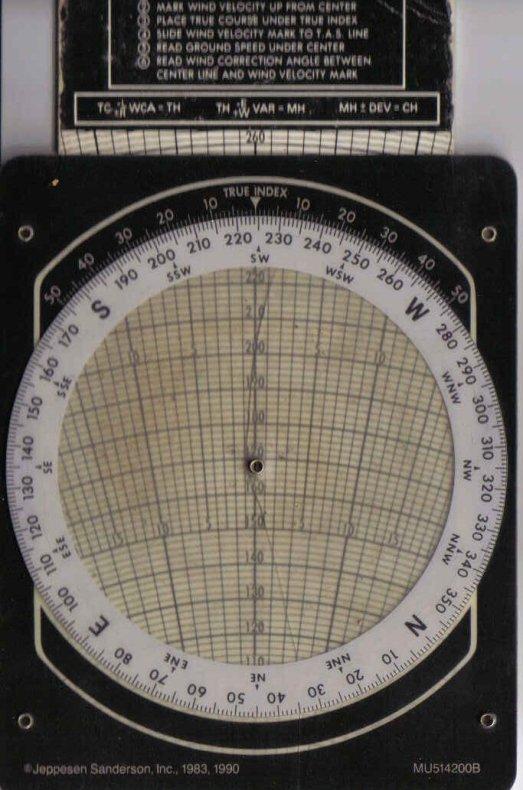
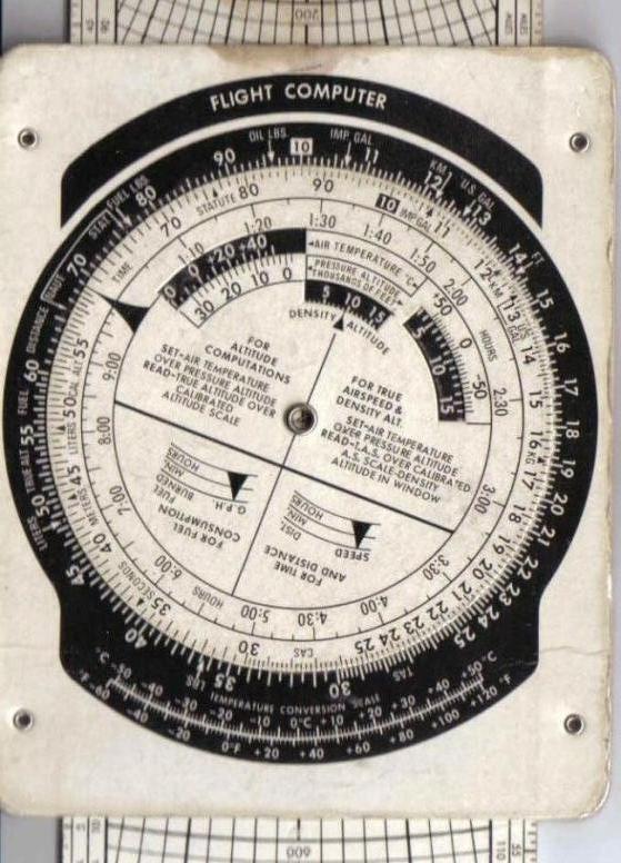
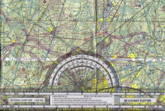
Rajiv: You could fake it by using the FS flight planner to figure out the distance between A and B and set a course line on the map just as you would on a real chart- (select "direct-GPS" after selecting your departure and destination airports  to make that line, then open the Nav Log to see the distance and course heading.), then  once you're sure you'll have enough fuel, you're on your way. If there's any wind, your actual heading may differ from the straight-line course; just splitting the difference between "true" course heading and wind direction will usually work well enough, although it depends  Other than that, it'd be the same as real-life "dead reckoning": You've got a heading to take you there, you know the distance, if you're lucky the map will have landmarks you can use as waypoints, and by monitoring your airspeed and fudging as necessary for wind, you can guess your ETA as you go. Without a chart and a plotter, not to mention a flight computer, it's not very precise, but it's workable.  Charts, plotters, and low-end flight computers (sort of a circular slide-rule in its simplest form, if you didn't know) are pretty inexpensive, and you can order both  from Sporty's or any number of pilot shops online.  The directions for the computer will tell you how to plan a flight and check your progress, allowing for wind, altitude, fuel consumption, etc. An aeronautical chart will show you magnetic variation for the area, which you should know to set an accurate heading to fly, as opposed to a straight-line heading (your compass always shows magnetic north, not geographical north).  But for short flights, any map, a compass, and a clock are all you really need for VFR flight.

This is the time&distance side of a cardboard flight computer (E6B):
Image

This is the wind side:
Image

This is part of the (old- not suitable for navigation!) New York Sectional chart with a plotter:
Image

I know that's a bit much, but if you really want a realistic ded. reckoning VFR experience, these are the tools you'll need to do it precisely. There are World Area charts which show a lot more area (but less detail) than sectionals, and they're good for planning even short flights... you'll get more for your money, as they're the same price.
Last edited by beaky on Fri Jan 07, 2005 9:35 pm, edited 1 time in total.
Image
User avatar
beaky
Global Moderator
Global Moderator
 
Posts: 12877
Joined: Thu Dec 16, 2004 8:00 am
Location: Shenandoah, PA USA

Re: Navigation

Postby beaky » Fri Jan 07, 2005 9:47 pm

I re-read your question, rajiv, and realized I'd missed something... You can download charts some places (sorry no links), but they're not free. Some sites have sample (outdated) charts you can get for free, but that's probably not what you're looking for. A regular map might do the trick, but aero charts have that extra info. that really helps. Even if you're not going to navigate via VORS, the VORs are shown with a "compass rose" which you can look at to guess what the true course heading is for your intended route, if there's one near your line. The magnetic variations are important, too, if you're just going to use the compass to determine which way you're going- they're also shown on aeronautical charts, as well as ALL airports, their elevations and runway lengths, controlled, restricted and prohibited airspaces, heights of mountains, etc., etc. With just an aero chart you could probably do OK without all the other stuff I mentioned in my previous post...
Image
User avatar
beaky
Global Moderator
Global Moderator
 
Posts: 12877
Joined: Thu Dec 16, 2004 8:00 am
Location: Shenandoah, PA USA

Re: Navigation

Postby MattNW » Fri Jan 07, 2005 10:45 pm

[quote]Charts, plotters, and low-end flight computers (sort of a circular slide-rule in its simplest form, if you didn't know) are pretty inexpensive, and you can order both
Last edited by MattNW on Fri Jan 07, 2005 10:47 pm, edited 1 time in total.
In Memory of John Consterdine (FS Tipster)1962-2003
User avatar
MattNW
Major
Major
 
Posts: 1705
Joined: Tue Mar 25, 2003 2:34 pm
Location: Indiana

Re: Navigation

Postby beefhole » Fri Jan 07, 2005 11:10 pm

Lol, the WIZ WHEEL! I asked a CFI at my airfield (one other than my own instructor) to help me with it and they all erupted into laughter... apparently it's not "cool" in the aviation world to be using an old jepp flight computer. And with me, it's downright dangerous. I keep forgettin how to do things on it...
User avatar
beefhole
Major
Major
 
Posts: 3804
Joined: Thu Jun 05, 2003 8:57 am
Location: Philadelphia

Re: Navigation

Postby beaky » Fri Jan 07, 2005 11:22 pm


Now those pics take me back a little. When I started flying that was about all you had to plan with. Electronic flight computers were available but a decent one would set you back about $999 to $3000 (a regular +,-,* and / pocket calculator cost close to $300). Suffice it to say most GA joyride pilots just used what's in your pics.  

Showin' my age here aren't I? ;D


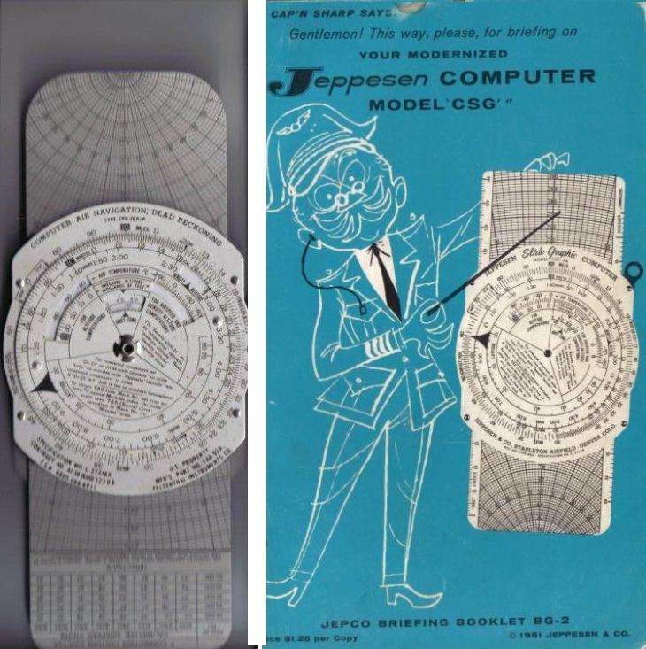
I've got about 200 hrs. RL flight time in light singles since 1995 , including a solo jaunt from NJ to Louisiana and back, and have never owned an electronic flight computer. Never even used GPS in flight except to check groundspeed. I enjoy ded. reckoning, and  once I learned to use a "whiz wheel" I didn't have much interest in using anything else for VFR planning or changes in flight. There are three great things about these things: They don't have batteries, they're cheap, and if you sit on one or drop it, it won't break. As far as speed and precision goes, the only weak point is the pilot's brain.  And if you think that 10-year-old E6B is a blast from the past, dig this gift I got from a friend for this last Xmas:
Image
On the right is the cover of the whimsically-illustrated manual, published 1961. I'd imagine the computer was made the same year. It's just a wee bit older than I am, but unlike myself, this thing seems unused, except for a pencil mark on the wind side. It's very nicely made out of aluminum. Haven't used it yet, in flight or in sim, but I will. BTW, I think the electronic jobs cost a lot less now (then there's all the cool PDA products out there). But these things can do anything the electronic ones can do, are cheaper,sturdier, and don't need batteries.
Wait a minute- a $300 pocket calc? Jeez, I thought I was old!! ;)
Image
User avatar
beaky
Global Moderator
Global Moderator
 
Posts: 12877
Joined: Thu Dec 16, 2004 8:00 am
Location: Shenandoah, PA USA

Re: Navigation

Postby MattNW » Fri Jan 07, 2005 11:23 pm

Lol, the WIZ WHEEL! I asked a CFI at my airfield (one other than my own instructor) to help me with it and they all erupted into laughter... apparently it's not "cool" in the aviation world to be using an old jepp flight computer. And with me, it's downright dangerous. I keep forgettin how to do things on it...


"Cool" or not those things or ones very much like them pushed aircraft all over the globe dating back as far as WW II and earlier.  ;D
In Memory of John Consterdine (FS Tipster)1962-2003
User avatar
MattNW
Major
Major
 
Posts: 1705
Joined: Tue Mar 25, 2003 2:34 pm
Location: Indiana

Re: Navigation

Postby beefhole » Fri Jan 07, 2005 11:30 pm

I'm very well aware of that... it doesn't mean its hip today.  Gotta stay with the times. And I seriously shouldn't be using one, my times were all off last cross-country...
User avatar
beefhole
Major
Major
 
Posts: 3804
Joined: Thu Jun 05, 2003 8:57 am
Location: Philadelphia

Next

Return to FS 2004 - A Century of Flight

Who is online

Users browsing this forum: No registered users and 812 guests