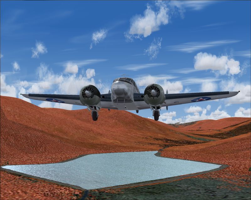
I messed around for a few hours to see what I could do with the XML SDK. Came up with a nice little scenery using all default objects as you can see. I plonked it somewhere in the Northern Territories at S15 11.47, E135 32.29.
The beauty of this method is that you get your field listed in the Airports list which is quite handy
The scenery contains a 600m dirt runway with markings, Grnd and Tower comms and an NDB, a building with a water tower, a fuel tank and a parked truck which isn't bad for a rough strip.
It's all done with a little XML file that is converted into a bgl file of only 32k. There are no textures to worry about as they are all default objects.
Only one problem - you still need to have an exclude to take out all the trees that would otherwise be all over the runway, and as I did that with Airport, I also put a flatten in as well otherwise you have the old problem of a bouncy runway that can break undercarriages.
So this is one way to do it. You could just use AFCAD if you don't want any buildings or Airport for everything if you want to find and place some suitable macros for things like the truck, building, watertower and so on. That's probably the best way actually as you will need an exclude and flatten for every strip and once you have found suitable objects you can just mix and match and place them at different spots to vary the look of each strip.
That's how I would do it anyway, but obviously you would need to learn a little bit about scenery design to do it successfully.
For anyone interested, here's the XML coding for the scenery.
version="9.0"
xmlns:xsi='http://www.w3.org/2001/XMLSchema-instance'
xsi:noNamespaceSchemaLocation="bglcomp.xsd">
lat="S15 11.4857"
lon="E135 32.3248"
alt="0"
altitudeIsAgl="TRUE"
pitch="0"
bank="0"
heading="21.2"
imageComplexity="SPARSE">
name="d74829dc41da57eeee6bb4954eb560b8"
scale="1.1"/>
lat="S15 11.4700"
lon="E135 32.3245"
alt="0"
altitudeIsAgl="TRUE"
pitch="0"
bank="0"
heading="0"
imageComplexity="SPARSE">
name="93802d8b45ebba4f029f72a2b3ee0f9a"
scale=".4"/>
lat="S15 11.4950"
lon="E135 32.3256"
alt="0"
altitudeIsAgl="TRUE"
pitch="0"
bank="0"
heading="111.2"
imageComplexity="SPARSE">
name="f51fb5e44a8eb23b924c15a579c16c17"
scale=".5"/>
lat="S15 11.4800"
lon="E135 32.3245"
alt="0"
altitudeIsAgl="TRUE"
pitch="0"
bank="0"
heading="171.2"
imageComplexity="SPARSE">
name="539ca4984287ec1f849c0a98aa4cd7a0"
scale=".9"/>
region="Oceania"
country="Australia"
state="Northern Territory"
city="Aussie Creek"
name="Aussie Creek"
lat="S15 11.4700"
lon="E135 32.29"
alt="10.1"
magvar="-8.8"
ident="AUS1">
lat="S15 11.4857"
lon="E135 32.3248"
alt="22"/>
frequency="119.85"
type="TOWER"
name="AUS1 TOWER"/>
frequency="122.95"
type="GROUND"
name="AUS1 GROUND"/>
lat="S15 11.4583"
lon="E135 32.2667"
alt="10.1"
type="COMPASS_POINT"
frequency="290.0"
range="50000"
magvar="-8.8"
region="A"
ident="AUZ"
name="AUS1">
heading="25.0"
imageComplexity="SPARSE"
name="5a003f364f9768dd6861b3b0859a7763"/>
lat="S15 11.4700"
lon="E135 32.29"
alt="10.1"
surface="DIRT"
heading="21.2"
length="600"
width="40"
number="3"
designator="NONE"
patternAltitude="200"
primaryTakeoff="YES"
primaryLanding="YES"
primaryPattern="LEFT"
secondaryTakeoff="YES"
secondaryLanding="YES"
secondaryPattern="RIGHT">
edges="TRUE"
threshold="TRUE"
touchdown="TRUE"
dashes="TRUE"
ident="TRUE"
precision="TRUE"
edgePavement="FALSE"
singleEnd="FALSE"
primaryClosed="FALSE"
secondaryClosed="FALSE"
primaryStol="FALSE"
secondaryStol="FALSE"/>
type="RUNWAY"
lat="S15 11.5212"
lon="E135 32.2900"
alt="10.1"
heading="21.2"
end="PRIMARY"/>
type="RUNWAY"
lat="S15 11.3414"
lon="E135 32.3416"
alt="10.1"
heading="201.2"
end="SECONDARY"/>

 PhotoShop 7 user
 ...!
...!
 Intel i7 960 quad 3.2G LGA 1366, Asus P6X58D Premium, 750W Corsair, 6 gig 1600 DDR3, Spinpoint 1TB 720